


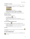
Customizing the Map and Tab Display
43
number (needed when purchasing quads), right-click a point within the
quad and then click Info. An information box displays in the lower-
right corner of the screen.
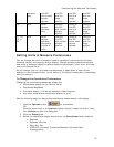
• 3DTQ Region Coverage—Displays the DeLorme 3DTQ product CD
volume label, which covers each map area at data zoom level 10-0 or
greater.
• Map Center Crosshair—The map center crosshair indicates the map
center at any data zoom level.
• Exits—View exits on primary limited access roads, interstates, and toll
roads. Available at data zoom level 10-0 or greater.
• One Ways—One ways display as bright green triangles on roads,
pointing toward the direction of travel (most noticeable in large cities).
They are available at data zoom level 13-0 or greater.
• Places (Minor)—View smaller towns, suburbs, locales, and natural
features. Zoom levels vary.
• Roads (Minor)—View secondary roads, local and rural routes, trails,
and railroads. Zoom levels vary.
• Points of Interest
• Major—View many different points of interest, including
recreational areas, public safety, rest areas, and more.
• Minor—View general points of interest including educational,
technology, government, and religious buildings/locations.
• Business (Major)—View many different travel-related points
of interest including hospitals, camping, restaurants, and more.
• Business (Minor)—View general points of interest including
small shops and food stores, laundromats, and golfing.
• ZIP-Postal Codes—ZIP/Postal Code boundaries display at data zoom
level 8-0 and greater, with ZIP/Postal Code labels displaying at data
zoom level 10-0 and greater.
• Town Borders—View town borders at data zoom level 10-0 and
greater for the following states:
Arkansas
Connecticut
Illinois
Indiana
Iowa
Kansas
Louisiana
Maine
Maryland
Massachusetts
Michigan
Minnesota
Mississippi
Missouri
Nebraska
New
Hampshire
New
Jersey
New York
North
C
arolina
North
Dakota
Ohio
Pennsylvania
Rhode
Island
South
Dakota
Vermont
Virginia
Washington
DC
West
Virginia
Wisconsin
• County Borders—View shaded outlines of U.S. counties at data zoom
levels 7-0 or greater.
• International Labels—View country labels at data zoom levels 0-0
through 4-0.
• Urban Area Color—Displays a shaded map area in populated regions
at data zoom levels 5-0.