


Using the Draw Tools
249
5. If you want to create an exact copy of the original file, select the layer type
that matches the original file. GIS Layer has options for New Layer, Append
Layer, and Replace Layer. When you select an option, the Import Source
Selection dialog box opens so you can define the import parameters.
A new file is created and inserted into the table.
OR
If you want to copy the file and save it as a different layer type, select the
option you want.
A new file is created and inserted into the table.
Tip You can also change a draw object type using the right-click feature. For more
information, see Changing Draw Object Types.
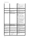
Changing Draw Object Types
When you add a draw object to the map, a draw file is automatically created that
includes that object. The draw file type varies depending on the draw object that was
created.
Note Routable roads require a routable DeLorme dataset. Routable trails require a
topographic DeLorme dataset. For information, visit www.delorme.com or call
DeLorme Direct Sales at 800-561-5105.
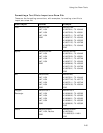
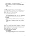
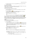
Draw Object Type Draw File Type
Routable Road Road Layer
Routable Trail Trail Layer
Waypoint Waypoint Layer
Track Track Layer
Area Object (Polygon, Circle, Rectangle)
Point Object (MapNote, Text Label,
Symbol, Image)
Line Object (Line, Arc, Spline)
Draw Layer
You can right-click a draw object on the map and change it to a road, track, trail,
waypoint, or draw layer, depending on the type of draw object you selected. When
the draw file type is changed, the original draw file is maintained and a copy is made
and switched to the new draw file type, leaving you with two files: the original draw
file and the copied draw file, which has a new draw file type.
To Change a Draw Object
Use the following steps to change a draw object type.
1. Use the Draw tab to place a draw object on the map.
2. To change a routable trail, track, or line to a road layer, right-click the object
on the map, point to Manage Draw, and then click Copy to Active Road
Layer.
OR
To change a routable road or routable trail to a track layer, right-click the
object on the map, point to Manage Draw, and then click Copy to Active