


193
Printing
Printing a Map
You can print a 2-D or 3-D map based on your paper size or screen size. If you
choose to print a map based on your paper size, you can also print a multi-page map
that you can assemble using the Manually Assembling a Multi-page Map instructions.
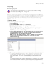
To Print a Map
Use the following steps to print a map.
1. Locate the area you want to print.
2. Click the Print tab.
3. Click the Map subtab.
4. Under Map, select Left map, Right map, or Both maps.
Note If the left or right and/or both options are unavailable, it is because
only one map view is displayed. To make all selections available, use the map
resize tool to expose the left and right map views. To print a full-page 3-D
map, use the map resize tool to expose only the left map window.
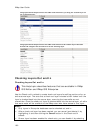
5. Under Print Layout, select Page (the map print area is based on the paper
size you have specified in the Setup options) or Screen (the map print area is
based on the screen size).
The print area for a Page map displays as a red box on the map, which may
not always be visible. The overview map and the print area for a Screen map
display as a blue box on the overview map.
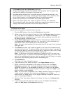
6. If you selected Screen in step 5, go to step 7. If you selected Page in step 5,
the following options are available.
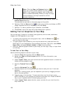
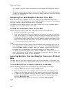
• Under Print Layout, select a layout option (Single, 2 x 2, or 3 x 3).
The print area displays on both the map and the overview map.
• If you selected 2 x 2 or 3 x 3 on the map layout graphic, and you do
not want to print all the pages in the multi page map, click each page
you do not want to print. The page appears dimmed or gray. (You can
click a dimmed/gray page again to print it.)
Note In the example below, page 4 will not print for the 2 x 2 map.
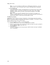
• Verify this is the location and photo zoom you want to print.
• If not, pan the map to a new location and zoom to the correct
level.
OR
• To change the photo zoom, select an option from the Photo
Zoom drop-down list or type the photo zoom in the text box.
Note Changing the photo zoom enlarges or reduces the map
features and changes the map print area. If you increase the
photo zoom level, map text, lines, symbols, etc. display larger
and your map print area is reduced. If you decrease the photo
zoom level, map text, lines, symbols, etc. display smaller and
your map print area is enlarged. The reduction/enlargement