


XMap User Guide
304
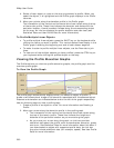
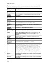
This table describes the statistic options available in the statistic list and/or the
profile info box. List options are bold.
Statistical
Data Option
Description
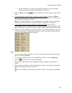
Linear
Distance*
The flat distance of the profile. Does not take elevation into
account.
Terrain
Distance*
The 3-D distance of the profile accounting for elevation rise
and descent.
Climbing
Distance*
The total distance where the terrain is uphill.
Descending
Distance*
The total distance where the terrain is downhill.
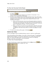
Current
Elevation
The elevation above sea level at a specific point.
Elevation
Gain*
The difference in elevation from the start of the profile to the
end of the profile.
Climbing
Elevation
The amount of ascending vertical distance.
Descending
Elevation*
The amount of descending vertical distance.
Grade Actually percent grade, rise over run (100 x (rise/run)). For
example, 6 means that for every 100 ft, you gain 6 ft in
elevation.
Average
Grade*
Average of the grade from the start to the current cursor
position (or finish).
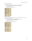
Minimum
Elevation
The elevation of the lowest point on a profile.
Maximum
Elevation
The elevation of the highest point on a profile.
Zone** A named grid system of any of the UTM/UPS, MGRS, or State
Plane coordinate systems used as a basis for coordinate
display. For example, UTM zone 19 specifies the six-degree
swath between longitude 66W to 72W and running from 84S
to 80N. Another example is zone ME-W in the State Plane
coordinate system, which specifies an area that covers the
western half of Maine. When using one these coordinate
systems, the current zone and coordinates east and north (the
eastings and northings) of the zone origin are displayed.
Easting** The measure of a position relative to the x-axis (horizontal) of
a grid system.
Northing** The measure of a position relative to the y-axis (vertical) of a
grid system.