


XMap User Guide
18
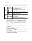
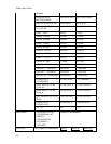
To Zoom In/Out Using the Zoom Tools
There are two sets of zoom tools. The zoom tools for the right map are located in the
Control Panel. The zoom tools for the left map are located at the top of the left map
view.
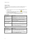
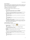
Click the up arrow to zoom out one minor data zoom
level at a time. Click the down arrow to zoom in one
minor data zoom level at a time.
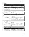
Click the Zoom In 1 tool to increase the detail
number to the next full level.
Click the Zoom Out 1 tool to decrease the detail
number to the next full level.
Right
Map
Controls
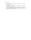
Click the Zoom Out 3 tool to decrease the detail
number by three full levels.
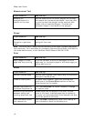
Left
Map
Controls
Click the plus button to increase the detail number to
the next full level.
Click the minus button to decrease the detail number
to the next full level.
The data zoom level of the left map displays in the
text area to the left of the buttons.
Tips
• Press ALT+PAGE UP on your keyboard to zoom out to the next full data zoom
level. Press ALT+PAGE DOWN on your keyboard to zoom in to the next full
data zoom level.
• Use the mouse wheel to zoom the map in and out. Rotate the mouse wheel to
zoom in by individual data zoom level steps or hold the SHIFT key while
rotating the mouse wheel to zoom to the next full data zoom level.
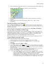
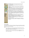
Panning/Centering the Map
Use any of the following methods to pan (move) or center the map.
• Click anywhere on the current map view. The point you click becomes the
new map center.
• Double-click a layer name in the GIS workspace.
• When you point near the map edge, a white hand displays. Drag the hand to
move the map in that direction.
• Click the Grab and Pan button
on the toolbar to drag/pan the 2-D or 3-
D map in any direction.
• Click anywhere on the overview map. The point you click becomes the new
map center. This allows you to traverse greater distances with each mouse
click than you can within the main map.