


Using the Draw Tools
267
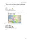
a new location. When you select a shape point of a line segment within an
active polygon, a small green circle indicates the start end point of the
selected line segment and a small red circle indicates the last end point of the
selected line segment. Select the Coordinate option or the Distance and
Bearing/Angle option and edit their numbers. Click Apply to initiate the
changes.
Notes You can display either bearing or distance by clicking the drop-down
arrow next to the Bearing or Angle text located below the distance text in the
Distance and Bearing/Angle option. You can also delete points and line
segments from or add points to a polygon.
6. Press the ENTER key on your keyboard to finish your edit.
OR
Click outside the object's active box on the map.
Placing a Circle, Rectangle, or Polygon on the Map
You can place any area object (circle, rectangle, or polygon) at a specific coordinate
location.
To Place an Area Object on the Map
Use the following steps to place a circle, rectangle, or polygon on the map.
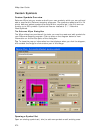
1. Click the Draw tab.
2. Click and hold the Polygon/Rectangle/Circle tool
and select
the tool you want.
3. Select the circle fill, outline, and/or width options.
4. To place a circle on the map, enter the coordinates for the circle's center into
the corresponding text boxes. Then, enter the radius for the circle into the
radius text box.
OR
To place a rectangle on the map, select the Coordinate option or use the
Distance and Bearing/Angle option in conjunction with the Coordinate
option. Enter the appropriate coordinates or numbers for the rectangle's
upper-left corner point into the corresponding text boxes to the right of the fill
options box.
OR
To place a polygon on the map, select the Coordinate option or use the
Distance and Bearing/Angle option in conjunction with the Coordinate
option, and enter the appropriate coordinates or numbers for the first polygon
point into the corresponding text boxes to the right of the fill options box.
5. Click Apply.
Note If you are placing a polygon on the map, repeat the procedure for the
other points.
Waypoints, Symbols, MapNotes, Text Labels, and
Images
Adding a Waypoint, Symbol, MapNote, Text Label, or Image to the
Map
You can add point draw objects to a draw file in your current project. Point objects
consist of one anchor point attached to a waypoint, symbol, MapNote, image, or text