


Using the Draw Tools
247
Viewing the Contents of a Draw File
Once you create a draw file (draw, road, trail, waypoint, or track layer), you can
view the contents of that file using the More button in the File view of the Draw tab.
Note Routable roads require a routable DeLorme dataset. Routable trails require a
topographic DeLorme dataset. For information, visit www.delorme.com or call
DeLorme Direct Sales at 800-561-5105.
To View the Contents of a Draw File
Use the following steps to view the contents of a draw, road, trail, waypoint, or track
file.
1. Click the Draw tab.
2. Click File to open the draw file editing area.
All the files you have created display in a table. A draw file with a selected
check box displays on the map.
3. Click to select the file that includes the contents you want to view.
4. Click More.
The tab area increases in height and the file contents table displays. The
information that displays in the table is dependent on the file type that is
selected.
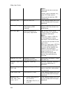
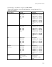
• Draw layer contents include the draw object label (name), comments
about the draw object, the URL assigned when the draw object was
added to the map, the date and time the object was last modified, and
the draw object type (symbol, line, polygon, circle, etc.).
• Road layer contents include the routable road name, comments about
the routable road, the URL assigned when the routable road was added
to the map, the date and time the routable road was last modified, and
the length of the road (in the measurement chosen in the Display
settings).
• Trail layer contents include the routable trail name, comments about
the routable trail, the URL assigned when the routable trail was added
to the map, the date and time the routable trail was last modified, and
the length of the trail (in the measurement chosen in the Display
settings).
• Waypoint layer contents include comments about the waypoint, the
URL assigned when the waypoint was added to the map, the date and
time the waypoint was last modified, the coordinates of the waypoint,
the elevation of the waypoint, and the symbol name.
• Track layer contents include comments about the track, the URL
assigned when the track was added to the map, the date and time the
track was last modified, the start and finish time of the track, the total
time of the track, the distance of the track (in the measurement
chosen in the Display settings), and the number of readings that the
track includes.
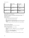
5. Optional. Double-click a draw object in the table to center the map on its
location.
OR
Right-click the draw object in the table and click Go To.
6.
Optional. To sort the columns
of data in the table in ascending order, click the
column header. Click the column header again to sort in descending order.