


Using Handheld Devices
363
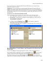
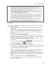
2. Double-click the user raster data you want to send to the device.
Selected data appears on the map.
3. Click the Handheld Export tab and zoom to the area of interest on the map.
4. Click the Options button to open the Handheld tab in the Options dialog box.
5. Under Export Map Format, select DeLorme Earthmate.
6. Under Export Map Source, select the map with the draw layer (Left or
Right).
7. Under Export Data Zooms, select Draw Layers.
8. Choose the zoom ranges at which you want to view the data at on the
handheld device.
9. Click Select/Edit
to select the grids that cover the draw layers
you want to send to the device.
You can use the Grid Size control to modify the grid size. When selecting
grids, you will receive an error in the Info box if the map output is too large.
You can select fewer grids or adjust the Draw Layers zoom ranges to reduce
the map output size.
To Send User Raster Data
To send a map package with user raster data to your device, see the Help topic for
your device:
• Sending/Receiving Maps to/from an Earthmate PN-40
• Sending/Receiving Maps to/From an Earthmate PN-20
Notes
• XMap USA Topographic Data
(All vector data (points, lines, and polygons) in
DeLorme Topographic datasets and all user vectors on the map (GIS layers,
XData datasets, MapTags, Phone book points, and so on). The Topographic
data must be installed separately from the XMap application. If you do not
have this data installed, you do not see this option.) includes GIS data and
any other vector data on the map. This data is saved at a low resolution, so
lines and polygons may not be clear at higher zoom levels on the device;
however, the data is smaller in size.
• Vector data (points, lines, polygons) may look slightly different in the
software than on the device.
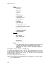
• Lines
• Blazed Trail
• Sewer Line
• Water Line
• Drain Line
• Gas Line
• Electric Line
• Telephone Line
• Ticked Fence
• Post and Rail Fence
• Barbed Wire Fence
• Guard Rail
• Stone Wall