


XMap User Guide
26
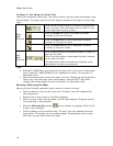
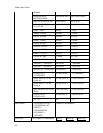
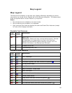
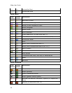
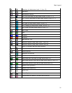
Toolbar
Use the toolbar to perform many functions in the application without navigating
through the tab area.
*These tools are available only in XMap Editor and XMap Enterprise.
**These tools appear only when an active database subscription exists.
Exchange
• Exchange routes, waypoints, or tracks with a GPS or PDA.
Note The GPS and Exchange groups are combined into the GPS/Exchange
group in XMap Professional.
GeoTagger
• Combine images and data with GPS information on the map.
GIS Layer Management
• Import a layer into a database from a file or ArcSDE database.
• Add and remove layers from your workspace, delete layers from the source
database, or remove a database reference.
GIS Tools
• Select a layer from your workspace as the active layer.
• Save all your changes to the active layer.*
• Select geometries on the map without risk of accidental editing.
• Analyze the topographical relationship of lines based on their attributes.
• Move or change the size of a geometry.*
• Edit points in a polygon/line layer.*
• Rotate a geometry.*
• Add geometries to a layer.*
• Build polygon, line, or point geometries by coordinates, angle/distance
measurements, or bearing/distance measurements.*
• Modify the class for a selected geometry or automatically create geometries
as with a specified class.*
GPS
• Start or stop your GPS connection (also available on the GPS tab).
• Turn GPS NavMode on or off.
Note The GPS and Exchange groups are combined into the GPS/Exchange
group in XMap Professional.