


XMap User Guide
298
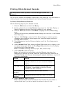
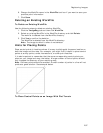
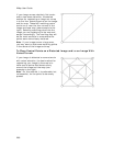
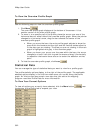
If your image covers relatively flat terrain
and/or has some distortion, the easiest
method for registering an image on a map
is to find four matching points on the image
and the map. These four matching points
can be on or near the four corners of the
image and base map (see example to the
right). Selecting matching points ties the
image you are registering to the map and
warps it accordingly. The resulting map will
be the most accurate in areas where the
points were more closely matched.
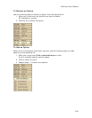
Note If your image covers a large area,
you may want to add some matching points
in the center of the image and map.
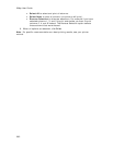
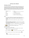
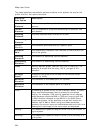
To Place Control Points on a Distorted Image and/or an Image With
Varied Terrain
If your image is distorted or covers terrain
with varied elevation, the best method for
registering your image to the map is to
have control points distributed evenly
around the image and the map (see
example to the right).
Note For this method, it is preferable, but
not essential, for the points to be evenly
spaced.