


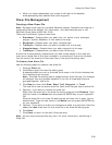

Using the Draw Tools
235
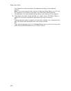
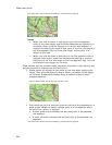
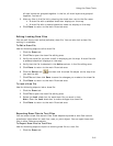
• A small green circle indicates the start end point of the selected
line segment.
• A small red circle indicates the last end point of the selected line
segment.
The same spline with end points indicating a selected spline segment.
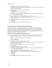
Notes
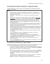
• When you click the start or last end point of the line segment
within a line draw object and the Show Measurement check box is
available (when using the Polygon or Line tool) and selected, it
displays the bearing or angle of that point of the line, the length of
the line segment (leg), and the total length of the entire line
object on the map.
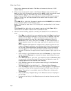
• When you click the start or end point of the line segment within a
polygon draw object, a text box displays the bearing or angle of
that point of the line, the length of the line segment (leg), and the
total area of the polygon on the map.
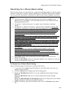
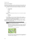
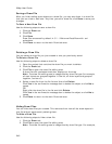
Draw objects such as routable roads, routable trails, tracks, lines, splines, and
polygons consist of shape points and end points.
• Shape points are the points you place on the map when creating the
object. They give the object its shape. When you select a draw object
on the map, shape points display along the active object as small
magenta squares.
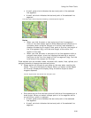
The line object below was drawn with the spline tool.
• End points are the first and last points of individual line segments on a
draw object. When you select a shape point of a line segment within
an active line, spline, or polygon:
• A small green circle indicates the start end point of the selected
line segment.
• A small red circle indicates the last end point of the selected line
segment.