


XMap User Guide
362
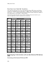
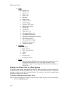
• Lines
• Blazed Trail
• Sewer Line
• Water Line
• Drain Line
• Gas Line
• Electric Line
• Telephone Line
• Ticked Fence
• Post and Rail Fence
• Barbed Wire Fence
• Guard Rail
• Stone Wall
• Vegetation Line
• Completed Dozer Line
• Line Break Completed
• Highlighted Geographic Feature
• Man Made Feature
• Uncontrolled Fire Edge
• Fire Break Incomplete
• Directional Arrow
• Polygons
• Wetlands
• Bare Ground
• Rock, Lake or Pond
• Island
• Land
• Mixed Forest
• Evergreen Forest
• Points
• Only Earthmate PN-Series point symbols are supported on the
PN-Series GPS devices. If you use other symbols in your
application, they will be changed to PN symbols for display on
the device.
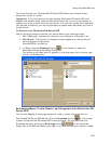
Adding User Raster Data to a Map Package
If you have user raster data (MrSID or GeoTIFF data files) that you want to send to
an Earthmate® PN-Series GPS device, you can use the Handheld tab in the Options
dialog to create a map that includes the data. You can then use the Exchange dialog
to send the map to the device.
To Create a Map with User Raster Data
Use the following steps to create a map with user raster data to send to the device:
1. Click the Map Data tab.