


XMap User Guide
156
2. Click the Workspace subtab if it is not selected.
3. Select (highlight) the layer you want to symbolize.
4. To open the Symbolize Layer dialog box:
Click the layer icon next to the layer name.
OR
Click the Tools button and then click Symbolize.
The Symbolize Layer dialog box opens.
OR
Right-click the layer and click Symbolize.
OR
XMap GIS Editor and Enterprise only Right-click a polygon on the map
and click Symbolize.
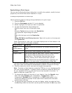
Under Symbolization, each row in the table displays each of the classes in the
layer. Each column in the table indicates:
This Column... Displays...
Field
name/Feature
The minimum and maximum (or unique) values of each
class.
Sample The current visual property for each class.
Legend Label The current label for each class. The Null Class indicates
any object whose attribute value falls out of the
classification. The Highlight Features label lets you
visually identify which records have been queried.
Note Records that are symbolized with a highlight are
saved in the layer when it is published to XMap Web.
The field you chose while classifying the layer displays each of the features for
that layer. Each of the features are selected to be shown on the map by
default.
5. Click the feature for which you want to change the properties.
Note To select multiple features, press the CTRL key on your keyboard while
you click multiple features. To select a block of features, press the SHIFT key
on your keyboard while you click the first and last records in the block. To
select all features, press CTRL + A.
6. To change the opacity of the color of your feature, from the Opacity drop-
down list, select Opaque (0% transparent), Transparent (100%
transparent), Blended (50% transparent), or XOR (combination of the
source and background pixels—most useful when records with the same
symbolization overlap).
Tip The Blended option is very useful for viewing polygons and map data.
7. To change the fill color of your feature, ensure the Show Fill check box is
selected, click the Fill Color button, and select a standard fill color or create
a custom fill color. To change the fill style for your feature using one of the
many hatch-fill options, click the Fill Style drop-down list and select a style.
OR
To hide the fill color on the map, clear the Show Fill check box.
8. To change the outline color of your feature, ensure the Show Outline check
box is selected, click the Outline Color button next to Outline under
Polygon Features, and select a standard line color or create a custom line
color. Then, select how wide you want your outline to display from the Width