


Working With GIS
169
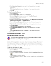
A floating arrow displays. Click the arrow and then select Open.
A message asks if you want to save or open the file.
6. Click Save to save the file to your hard drive (ensure that the Open in XMap
check box is selected).
The draw layer is added to your project and displays on the map.
OR
Click Open to open the file from its current location (ensure that the Open in
XMap check box is selected).
The draw layer is added to your project and displays on the map.
7. Use the notes and annotations in the draw layer to make the appropriate
edits to the corresponding GIS layers to which the user was subscribed.
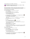
Using Right-Click Options in the Datasheet View
This Help topic describes features that are available in XMap
Professional, XMap GIS Editor, and XMap GIS Enterprise.
Several right-click options are available in the Datasheet View when you right-click
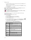
inside the attributes table. Below are the right-click options and their descriptions.
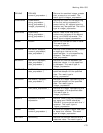
If you click this
right-click
option...
Then the following will result...
Zoom to Selection The map zooms to display all of the selected records.
Reverse Selection All of the selected records become unselected and unselected
records become selected.
Clear Selection Clears the selection.
Select All All of the records in the Attributes subtab are selected in the
attributes table and on the map.
Copy to Clipboard Each selected record in the attributes table is copied and can
be pasted into another program.
Place Point* When selected for a record, the corresponding point
geometry is selected with the Edit Tool, and the cursor
changes to the Edit tool. Click the map to move the point
from its previous location to the clicked location.
Geocode
Selection*
When selected, the selected records are re-geocoded (placed
on the map according to the attributes they were geocoded
by). This option is relevant when a user removes their map
data (Streets or Topo) after geocoding a layer during import,
and they edit the attributes of the geometry that were used
in geocoding.
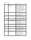
Zoom to Query
Results**
The map zooms to display all of the geometries that satisfy
the query results.
Zoom to Record The map centers on the selected record.
Refresh The attributes table refreshes (updates) to include any
changes that were made.