


395
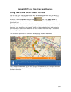
Using NetLink
NetLink Overview
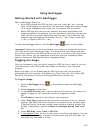
NetLink is an online portal within XMap®. You must have an Internet connection to
use NetLink.
The NetLink tab has four subtabs. Within each subtab, follow the on-screen
instructions or click the NetLink Help button
for more information.
Home
Purchase or activate a Map Library subscription, activate a Data Download Dollars
certificate, learn more about our data and imagery, and much more.
Map Library
Purchase Methods
• Map Library subscription
The most cost-effective method for purchasing datasets is an annual DeLorme
Map Library subscription. For just $29.95 a year, you can download an
unlimited number of our available datasets.
• DeLorme Data Download Dollars certificate
Included with your purchase is a certificate for $40 worth of data downloads.
This gives you the opportunity to see how imagery and data can enhance
your maps.
• Purchase
You can always purchase downloads. If you prefer to receive your datasets on
DVD, you must use this method.
Datasets
The following datasets are available.
• USGS 1:24K (Scanned Maps)
7.5-minute, 1:24,000-scale quadrangle series.
• SAT10 (Satellite Imagery)
True-color 10-meter resolution imagery from the French based SPOT satellite
(Satellites d’observation de la Terre).
• Color DOQQ (Aerial Imagery
)
True-color 1-meter resolution digital aerial photography.
• USGS DOQQ (Aerial Imagery)
Black and white 1-meter resolution digital aerial photography.
• NOAA Nautical Charts (Scanned Maps)
Color bathymetric nautical charts produced by the National Oceanic and
Atmospheric Administration (NOAA).
• USGS Hi-resolution 133 City (Aerial Imagery)
Color aerial imagery over the country's largest metropolitan areas with a
resolution of approximately 1/3 meter (or about 1 foot).