


Getting Started
9
• Why do X marks display on the map when I calculate a route?
• When you place a route point in a location that isn't on a street, XMap
finds the closest street to that location, marks the space between the
point you clicked and the street with X marks, and starts the route at
the street.
• If you perform a Find for an address that is on a walkway and place a
route point on it, XMap finds the closest street to that location, marks
the space between the point you clicked and the street with X marks,
and starts the route at the street.
• Why are the tab area and control panel so narrow?
XMap was designed to accommodate resolutions of 1024 x 768 or higher. If
you are using a very high resolution (such as 1920 x 1200), the tab area and
control panel in XMap may appear to be very narrow. You can modify the size
of the map and tab area or use the Windows Control Panel to adjust your
display settings.
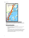
• What's the best way to measure the distance of a road or trail?
The best way to determine the distance of a particular road or trail, is to
create a route. You can create a route using right-click functionality, the
toolbar, or the Route tab. For more information, see Creating a Route.
The best way to determine the distance of a particular road or trail, is to
create a route. You can create a route using right-click functionality, the
toolbar, or the Route tab. For more information, see Creating a Route.
The best way to determine the distance of a particular road or trail is to
create a route. You can create a route using right-click functionality, the
toolbar, or the Route tab. For more information, see Creating a Route.
• What's the best way to measure a large area on the map?
The best way to measure a large area on the map is with the area tools in the
Draw tab, such as the polygon tool. When you draw an area object on the
map, the area displays next to the object on the map. If you click off of the
object, you can view the area again by clicking the Select tool in the Draw tab
and then clicking the area object on the map. For more information about
drawing area objects, see Drawing a Circle, Rectangle, or Polygon on the Map.
• What's the best way to measure a short distance on the map?
The best way to measure a short distance that is not made up of a road/trail
on the map is to use the Measure tool
on the toolbar. The measure tool
allows you to measure linear distance and area on the map based on the units
chosen in the Display tab of the Options dialog box. For instructions on how to
use the measure tool, see Measuring Distance and Area.
• Why won't 3-D billboards display?
If you receive a message saying that 3-D billboards cannot be displayed,
ensure that you have a 32 MB video card with the latest drivers and that it
supports DirectX and transparencies. For more information, see the DeLorme
Forums.