


354
Using Handheld Devices
Handheld Export
Setting Your Handheld Export Preferences
You can customize your map export options so that you export exactly the map data
types and data zoom level ranges you want to view on your handheld device or
Earthmate PN-Series GPS device.
Note You must have Street Atlas USA® Handheld installed to view exported maps
on a PDA.
To Set Your Handheld Export Preferences
Use the following steps to customize your map cutting preferences.
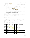
1. Click the Options button
on the toolbar (or click the menu
arrow and click Options) and then click the Handheld Export tab.
OR
Click the Handheld Export tab and click the Options button
.
2. Under Export Map Format and Location, select DeLorme Earthmate to
send maps to an Earthmate PN-Series GPS device.
OR
Under Export Map Format and Location, select Palm OS/Pocket PC to
send maps to a Palm OS or Pocket PC PDA.
Note Map packages are saved in the location displayed. To change where
you save map packages, click Browse and navigate to the new location.
3. Under Export Data Zooms, select the check box next to each map data type
you want to export. All user map data types are listed. For other data types,
only connected map data types are listed.
Tip XMap USA Topographic Data is the same data that is on the detailed data
DVDs that came with your PN-Series GPS. If you installed the detailed data
for the map you are creating, clear the XMap USA Topographic Data check
box so you do not duplicate data in your map.
4. Under Zoom Range, drag the slider controls to the minimum and maximum
data zoom levels at which to view the data.
5. For Draw Layers or GIS Layers, select Less Detail or Full Detail. Less Detail
creates a smaller file size and the data on the device has less detail than it
does on the map. Full Detail creates a larger file size and the data on the
device is identical to the data on the map.
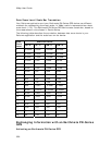
6. Repeat the steps for each selected map data type. The minimum and
maximum data zoom levels display to the right of each map data type.
7. Click OK to accept the changes and close the Options dialog box.
OR
Click Apply to accept the changes and remain working in the Options dialog
box.
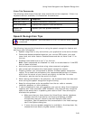
Notes
• Click Use Defaults to return the slider controls to their default minimum and
maximum values.
• Raster imagery (such as USGS Quads, aerial imagery, NOAA nautical charts,