


XMap User Guide
238
Viewing Hidden Draw Tools
The Draw tab tools allow you to add routable roads, trails, waypoints, tracks, lines
(straight lines, arcs, and splines), shapes (polygons, rectangles, and circles),
MapNotes, text labels, images, and symbols to a draw file. Some of these tools are
hidden tools available in pull-out menus.
Note Routable roads require a routable DeLorme dataset. Routable trails require a
topographic DeLorme dataset. For information, visit www.delorme.com or call
DeLorme Direct Sales at 800-561-5105.
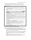
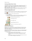
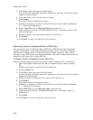
To View the Hidden Draw Tools
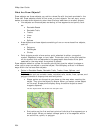
Five draw tool options have pull-out menus with hidden tools. These draw tools each
have a small arrow at the bottom-right of the draw tool button as shown in this
sample
.
Use the following steps to view the hidden draw tools.
1. Click the Draw tab.
2. Click and hold one of the visible tools shown below to display and select one
of the options. Selecting a hidden tool changes the default option.
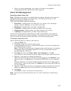
Routable Road/Routable Trail Tool
Tracks/Waypoints Tool
Line/Arc/Spline Tool
Polygon/Rectangle/Circle Tool
MapNote/Text Label/Symbol/Image Tool
Geocaching Features
Geocaching is a fun outdoor activity that uses a GPS device for treasure hunting.
Geocaching is enjoyed by all kinds of people—from families with small children to
active outdoor adventurers. You use your GPS device to follow clues to caches
hidden by other geocachers.
Your application has several features designed to enhance the interaction between a
GPS device and the cache information provided at Geocaching-The Official Global
GPS Cache Hunt Site.
• Use the import file option in the Draw tab to import:
• Geocaching.com Location (.loc) files. These files contain the cache
code, cache name, and the latitude and longitude for the cache
location.
• GPS Exchange (.gpx) files have full cache descriptions and hints that
you can view in the Waypoint comment field.