


Using Handheld Devices
355
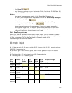
and satellite imagery) includes color-coded data zoom level suggestions under
Zoom Range.
• Green indicates the data zoom levels at which the data is best viewed.
The default values are set to only export data zoom levels that are in the
green area.
• Red indicates zoom levels at which the data is available but not
necessarily the best viewed.
• DeLorme Street Level Data and DeLorme Topographic Data are available
separately. For information, visit www.delorme.com or call DeLorme Direct
Sales at 800-561-5105.
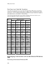
• Maps with multiple data types have large file sizes. To decrease the file size
when exporting multiple map data types, try exporting raster data with small
data zoom level ranges. The following list provides the optimum data zoom
level ranges for each raster data type:
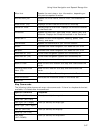
o GIS Layers
— 0-20
User GIS layers in the current GIS workspace. See Adding GIS Layers to a
Map Package for more information.
o Draw Layers
— 1-20
All draw layers in the current project, excluding waypoints and tracks. See
Adding Draw Layers to a Map Package for more information.
o User Raster Data
— 0-20
User MrSID and GeoTIFF data in the current project.
o Image Data Series
— 0-20
User raster data registered to the map using the ImageReg tab.
o DeLorme Topographic Data
— 9-17
DeLorme XMap USA Topographic Data. All vector data (points, lines, and
polygons), excluding draw objects, in DeLorme Topographic Data and all
user vectors on the map (XData datasets, MapTags, Phone book points,
and so on). The Topographic Data must be installed separately from the
XMap application. If you do not have this data installed, you do not see
this option.
o DeLorme USA Street Level Data
— 9-17
DeLorme XMap USA/Canadian Street Level Data. All vector data (points,
lines, and polygons), excluding draw objects, in XMap Street Level Data
and all user vectors on the map (XData datasets, MapTags, Phone book
points, and so on). The Street Level Data must be installed separately
from the XMap application. If you do not have this data installed, you do
not see this option.
Note DeLorme Street Level data is not included in the map if the Export
Map Format is set to DeLorme Earthmate.
o Satellite Imagery (SAT10)
— 9-11
True-color 10-meter resolution imagery from the French based SPOT
satellite (Satellites d’observation de la Terre). Downloaded using the
NetLink tab.
o USGS Quads (3DTQ)
— 12-14
Color contour topographic maps produced by the United States Geological
Survey. Downloaded using the NetLink tab.