


XMap User Guide
268
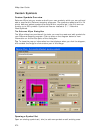
label. The anchor point is the pixel position on the symbol that corresponds to the
geographic coordinate of the point selected on the map when the symbol is placed.
• Use the Waypoint tool to label waypoints on a map. You can exchange
waypoints with a GPS receiver.
• Use the Symbol tool to identify certain areas on the map such as houses,
monuments, or points of interest.
• Use the MapNote tool to point to and label a specific area on the map. See
Map Notes for more information.
• Use text labels to name features or give details about features on the map.
• Use the Image tool to add, edit, or place .bmp, .jpg, and .gif images on the
map.
To Add a Point Object to the Map
• Add a MapNote, text label, or symbol
From the Draw tab:
1. Click and hold the MapNote/Text/Label/Symbol/Image tool and
select the tool you want. Then, select the font, style, size, and color
for your point object's label from the text style options.
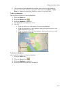
2. Click the location for the point object on the map.
The URL/Label text box opens.
3. Optional. Click the Hyperlink button
and browse to the document
you want to link your point object to. Then, click the file name and
click Open. The address appears in the URL field.
4. Type the name or phrase into the Label field. The coordinates or
distance and bearing/angle numbers of the location appear in the
corresponding Coordinate or Distance and Bearing/Angle text
boxes.
5. Press the ENTER key on your keyboard or click the map outside of the
object's active area when you are finished.
Notes
These steps describe how to add Draw MapNotes. To show/delete Route
MapNotes, see Setting Your Routing Preferences.
You can also add a MapNote by right-clicking the map on the point you want
to label, pointing to Add MapNote, and then selecting a MapNote option.
• Add a waypoint
From the Draw tab:
1. Click and hold the Tracks/Waypoints tool and select Waypoint
. Then, select the waypoint symbol from the Symbols options.
You can also select a different font, style, size, and color for the
waypoint name.
2. Click the location for the point object on the map.
The URL/Label text box opens.
3. Optional. Click the Hyperlink button
and browse to the document
you want to link your point object to. Then, click the file name and
click Open. The address appears in the URL field.
4. Type the name or phrase into the Label field. The coordinates or
distance and bearing/angle numbers of the location appear in the