


Viewing Your Map in 3-D
309
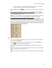
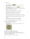
• Click anywhere on the square map in the Rotate graphic to move the
map in that direction.
• Click a directional letter (N, S, W, or E) to rotate the map in that
direction.
• Click the brown area that surrounds the square map to rotate the map
in that direction.
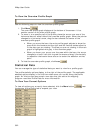
4. Use the Pitch controls to change the pitch of the 3-D map.
The pitch range depends on the terrain. 90° looks straight up, -90° looks
straight down, and 0° is horizontal.
You can control the pitch using one of the following methods:
• Press and hold the up arrow to increase the pitch.
• Press and hold the down arrow to decrease the pitch.
• Drag the reference arrow to the new pitch.
• Click anywhere on the graphic to update the pitch.
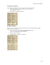
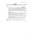
5. If you selected the Outside-looking-in perspective, you can adjust the
distance from the map center using the Distance up/down buttons, by
clicking the Distance graphic at the distance you want or by dragging the
numeric distance display in the Distance graphic.
OR
If you selected the Inside-looking-out perspective, you can adjust the
elevation of the view over the 3-D map using the Elevation up/down
buttons, by clicking the Elevation graphic at the elevation, or by dragging
the numeric elevation display in the Elevation graphic.
Note Elevation indicates the height above terrain, not the height above sea
level.
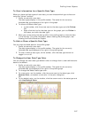
6. To pan the 3-D map and simulate a fly-over, drag the circle in the Pan
graphic in the direction you want.
7. Click Hide 3-D when finished.
The map changes to a 2-D view.
OR
Select 2-D from the drop-down list at the top of the left map window when
finished.
Tips
• When the 3-D map window is open, you can use the grab and pan tool on the
toolbar, Compass Rose navigation tools, zoom tools, and/or the overview map
window to adjust the 3-D map.
•
Scroll along the edges of the 2-D map or pan
with the navigation tools to
redraw the 2-D background; the 3-D map redraws with the new map center.
• Click a point on the 3-D map to center the map on that point.
• When you move your cursor on the right map, a 3-D cursor echoes that
movement on the left map.
Flying Over a 3-D Map
You can simulate flying over the 3-D terrain. Access these features using the Pan
feature in the 3-D tab or by activating the 3-D Navigation keyboard shortcut scheme.
To Fly Over a 3-D Map Using Keyboard Shortcuts
Use the following steps to fly over a 3-D map using keyboard shortcuts.