


XMap User Guide
120
UTM/UPS Type the applicable zone number and band letter
in the text boxes.
SPCS Select the applicable zone and units from the
drop-down lists.
Note If you select a coordinate format that does not match the data in the file
you are importing, the information area under Converted Boundaries displays,
"Invalid Boundary Coordinates."
12. Click Finish.
Note If you click Cancel while the progress meter is displaying, it cancels the
import process.
Append and Replace Examples
This topics provides additional information about appending and replacing imported
files. Go to Replace Examples.
Append
This import method is used to append, or merge, a new layer to an existing GIS
layer. The new layer must be of the same geometry type as the existing layer, and
attribute columns must have an exact name match in order to append to each other.
In addition, like-named attributes in the incoming layer must be of the same type
family in order to append. The importer will be as tolerant as possible within a type
family, allowing data to convert or widen. For example, a 100-character string
column in the source layer will widen to match a 200-character string in the target
layer, and vice versa.
The following list shows which attributes are compatible, and the direction of
compatibility:
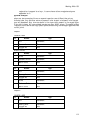
Boolean -> Byte -> Small Interger -> Interger -> Big Integer
String <-> URLs
String -> Memo
Float -> Double
Datetime
Document
Currency
Memo
Notes
• By definition, any attribute is automatically compatible with itself, and its
precision, if applicable, can widen or narrow.
• The master attribute and changes tables of the target layer are not emptied.
The incoming data is written to the primary attributes table. The changes
table has an entry written to it for each geometry that is added to the target
layer.
• Geocoded point layers can be appended only if all their attribute columns
match AND the source layer is geocoded by the same procedure as the target
layer (Address & Address, Zip Code & Zip Code, Lat/Lon & Lat Lon).
• Layers that are left unregistered during the import process and have not had
any registration applied to them after import can only have other
unregistered layers appended to them. This is possible for .dxf, .dwf, and
.dwg files that have no spatial reference to the earth surface. However, once