


233
Using the Draw Tools
Draw Overview
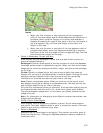
You can add draw objects, such as routable roads, routable trails, waypoints, tracks,
text, symbols, MapNotes, images, lines, arcs, splines, circles, polygons, and
rectangles to your map with the tools provided in the Draw tab. You can save draw
objects in a single draw file or in multiple draw files. You can view draw files
individually or with other draw files.
Note Routable roads require a routable DeLorme dataset. Routable trails require a
topographic DeLorme dataset. For information, visit www.delorme.com or call
DeLorme Direct Sales at 800-561-5105.
What is a Draw File?
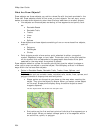
Imagine a draw file as a sheet of glass laying on top of your map. You can add
various objects to the draw file to help enhance or pinpoint specific areas on the
map, but these objects do not become part of the map. They exist in a draw file that
overlays the map.
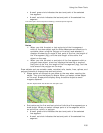
There are five different types of draw files: draw, road, trail, waypoint, and track.
You can create more than one draw file and overlay one on top of the other while still
viewing the map beneath. See Editing/Locking Draw Files.
When you clear or delete a draw file, the objects in the draw file do not display and
are deleted along with the draw file. When you create and save draw files, they are
saved within the current project.
Some additional draw file facts:
• A draw file is automatically generated the first time you add a draw object to
the map.
• As you create draw files, they are added to the current project.
• You can add draw files to multiple projects.
• You can control the creation of new draw files in the draw file editing area.
• Draw files are saved by default in C:\...\DeLorme Docs\Draw with the default
name; for example, DrawLayer#.an1, with # indicating the number order in
which the file was created. You can rename draw files to better identify your
specific information. See Creating a New Draw File.
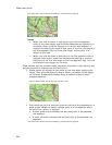
• You can have multiple draw files displaying at once while working on your
map. Work can be done on one draw file at a time, while viewing other files
beneath it. You can select different draw files to be the active, editable file
from within the Draw tab. For more information, see Editing/Locking Draw
Files.
• Draw files created in a particular project are displayed only if that project is
currently displaying. For example, if DrawLayer27 is created in a project
named Yarmouth Zoom 14 only, DrawLayer27 does not display if a project
named Old Port is currently displaying.
• Routable roads and routable trails are not tied to a project; they do not
change even when a project is changed.