


Profiling Linear Objects
305
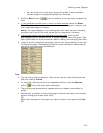
Latitude*** The measure of a position on the earth's surface north or
south of the equator in degrees, minutes, and seconds.
Defined as the angle from the equator's horizontal plane
perpendicular to the polar axis. Latitude is measured in
degrees minutes and seconds. All lines of latitude are parallel
and are often referred to as parallels.
Longitude*** The measure of a position on the surface of the earth east or
west of the Prime Meridian in degrees, minutes, and seconds.
Defined as the angle from the vertical plane running through
the polar axis and the prime meridian. Longitude is measured
in degrees minutes and seconds. All lines of longitude meet at
the poles and are often referred to as meridians.
*Calculated from the start of the profile to the current cursor position. If the cursor is not in the profile
area, then the value is calculated from the start of the profile to the end of the profile.
**This statistical information is available only if UTM/UPS, SPCS, USNG, or MGRS is selected as the
coordinate system in the Display tab of the Options dialog box.
***This statistical information is available only if a latitude/longitude format is selected as the coordinate
system in the Display tab of the Options dialog box.
Note For information on manually setting your minimum and maximum elevation,
see Manually Setting Minimum and Maximum Elevation.
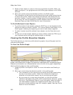
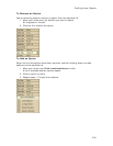
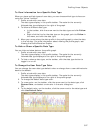
Manually Setting Minimum and Maximum Elevation
You can manually set a maximum or minimum elevation to display in your profile
graph.
To Manually Adjust Minimum and Maximum Elevation
Use the following steps to manually adjust minimum and maximum elevation.
1. Create a profile.
2. Click the More button
.
3. To control the maximum height displayed on the profile graph, under Manual
Scale, select the Max Elev check box and type the maximum height in the
text box.
This adjusts the top end of the vertical scale of the profile graph to not
display heights above the defined height.
4. To control the minimum height displayed on the profile graph, under Manual
Scale, select the Min Elev check box and type the minimum height in the
text box.
This adjusts the base level of the vertical scale of the profile graph to not
display heights below the height specified.
Note Distance displays in the units you set in the Options dialog box. For more
information, see Setting Units of Measure Preferences.