


29
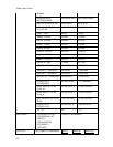
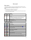
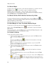
Map Legend
Map Legend
The features that display on the map may display differently depending on which
map colors you chose on the Display tab of the Options dialog box. The tables below
show the symbolization of each feature, by map color.
Notes
• Not all features are available at all zoom levels.
• Not all features are available in all datasets.
• High-contrast Color features display the same as Street Color features (except
for land, which displays as black).
Routable Trail Features
Topo
Colors
Street
Colors
Description
Major Trail
Important Some trails may cross private property. Contact
the applicable trail department to ensure you have the
appropriate permissions before following a major trail. For
contact information, see Recreational Contacts.
4-wheel Drive Trail
Trail/Walkway/Foot Trail
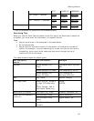
Routable Road Features
Topo
Colors
Street
Colors
Description
Ferry Passenger
Ferry Vehicle
Interstate Highway (can also include this symbol:
)
Limited Access Road
Local Road
Major Connector, Forest Road
Minor Connector
Non Limited Access Interstate
Primary State Route
State Route (can also include this symbol:
)
Toll Road
U.S./National Route (can also include this symbol:
)