


XMap User Guide
398
If you selected GPL File
, in the GPS Data box, type the path and file name for
the file or click Browse to search for the file on your computer.
7. Click Next.
The Image list displays the images that will be tagged. Click an image to
preview it in Image Preview window.
8. Under Time Offset, if the time on your camera differed from actual time
when you recorded the data, calculate the offset, type the actual time in the
Matching GPS Time text box.
9. Click Next.
10. Select how you want to place the image on the map.
• Hyperlink–A MapNote with a hyperlink to the image displays on the
map.
• Embedded–A MapNote with a thumbnail image hyperlinked to the
image displays on the map.
• Symbol–A camera symbol with a hyperlink to the image displays on
the map.
11. Click Next.
A message displays telling you that you successfully tagged your images.
Click Finish. When you view the GPS log file or track on the map, you can
see where the images are tagged.
OR
An error message displays; usually this is because the timestamps for the
camera and the file or track do not match.
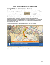
Tagging Data
Once you successfully tag your data to a GPS log file or track file, you can view the
points where the data was recorded on the map and in the Profile tab in your
DeLorme program.
Before you begin, you must download the GPS log file or track file and the data file
[Suunto (*.sdf), Timex Trainer CSV (*.csv), or Generic CSV File (*.csv)] to your
computer. See Receiving a Track From Your Third-party GPS Device for information
on using the Exchange Wizard to transfer files.
To Tag Data
1. Click the GeoTagger button on the toolbar to open the GeoTagger
Wizard.
2. Select Data File and click Next.
3. In the Data File Location box, type the path and file name for the file.
OR
Click Browse to search for the file on your computer.
4. Under Time Zone, select the time zone for your device.
If Daylight Saving Time was in effect (second Sunday in March through first
Sunday in November) when you recorded the data, select the Adjust for
Daylight Saving Time check box.
5. Under GPS Data, select Track or GPL File.
6. If you selected Track
, the list of track layers in the Draw tab displays in a tree
menu. Click the plus sign to expand the tree menu, and click the track. You