


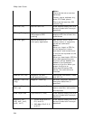

XMap User Guide
244
Notes
Files must be tab or comma-
delimited.
Format: name, address, city,
state, ZIP Code, phone.
Files must be less than 250
records long.
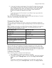
Text File (.txt) Lat/Lon Text File Draw objects display with the
current symbol and line style
selections.
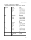
GPS Log File (.gpl) Any DeLorme product
that supports GPS
tracking
Line or waypoint object
displays with the current line
preferences.
GPX File (.gpx) DeLorme product on
third-party application
May contain one or more
routes, tracks, or waypoints,
as well as comments.
Notes
When you import a GPX file,
all the waypoints, tracks,
comments, and routes found
in the file are imported at the
same time.
When you download a GPX file
from www.geocaching.com,
the hints on the website are
added to the Comments
column of the file. When you
export the file to an
Earthmate PN series GPS
device, the comments are
included.
Location File (.loc) Waypoint file from
www.geocaching.com
Coordinate information, name,
and URL link.
Magellan Track File
(.log)
Magellan Track Log Latitude, longitude, elevation,
name and date/time (if
specified).
Magellan Waypoint
File (.upt)
Magellan Waypoint File Latitude, longitude, elevation,
name, comment, and symbol
are imported.
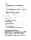
Draw Layer Files Topo USA 2.0 (.ano) Draw objects display with the
current symbol and line style
selections.
MapDocs (.sa7,
.sa8, .sa9, .mn5,
.mn6, .mn7)
Street Atlas USA 8.0,
8.0, and 9.0.
AAA Map'n'Go 5.0, 6,
and 8.0
Draw objects display with the
current symbol and line style
selections.