


XMap User Guide
364
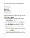
• Vegetation Line
• Completed Dozer Line
• Line Break Completed
• Highlighted Geographic Feature
• Man Made Feature
• Uncontrolled Fire Edge
• Fire Break Incomplete
• Directional Arrow
• Polygons
• Wetlands
• Bare Ground
• Rock, Lake or Pond
• Island
• Land
• Mixed Forest
• Evergreen Forest
• Points
• Only Earthmate PN Series point symbols are supported on the
PN series GPS devices. If you use other symbols in your
application, they will be changed to PN symbols for display on
the device.
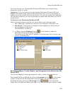
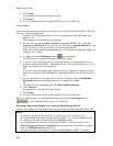
Deleting Maps, Waypoints, Routes, and Tracks
You can use the Earthmate PN-Series Exchange dialog box to delete maps,
waypoints, routes, and tracks from XMap® and from your Earthmate® PN-Series
GPS.
To Delete a Map, Waypoint, Route, or Track from XMap
To delete a route, waypoint, track, and map that is in your current project, click to
highlight the item (in the left pane of the Earthmate PN-Series GPS Exchange dialog
box) and then click the Delete button OR right-click the item and click Delete.
To Delete a Map, Waypoint, Route, or Track from an Earthmate PN-Series
GPS
To delete a route, waypoint, track, and map that is stored on your Earthmate PN-
Series GPS, click to highlight the item (in the right pane of the Earthmate PN-Series
GPS Exchange dialog box) and then click the Delete button OR right-click the item
and click Delete.
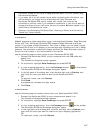
PN-40: Sending/Receiving Information
Sending/Receiving Maps to/from an Earthmate PN-40
You can use XMap® to send custom map packages to your Earthmate® PN-40.
Use the Handheld Export tab to create custom map packages of any size that cover
any location in the U.S. The data included in a custom map package is dependent on
the data that is available for the export area as well as the preferences made in the
Handheld Options settings.
Notes