


XMap User Guide
132
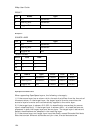
Modifying the Properties of a Layer
This Help topic describes features that are available in XMap
Professional, XMap GIS Editor, and XMap GIS Enterprise.
Use the Layer Properties dialog box to modify a layer's name, minimum and
maximum data zoom levels, geometry shape, layering level and more.
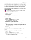
To Modify the Properties of a Layer
Use the following steps to modify the properties of a layer.
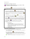
1. Click the GIS tab.
2. Click the Workspace subtab if it is not selected.
3. Click the layer for which you want to view/modify the properties.
4. Right-click the selected layer and then click Properties.
The Layer Properties dialog box opens.
OR
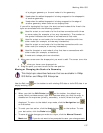
Click the Tools button and then click Properties.
The Layer Properties dialog box opens.
5. To change the layer's name, type a new name in the Layer Name text box.
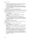
Tip You can also change a layer's name in the workspace table by clicking
the layer name twice. Be sure to click the layer name twice instead of double-
clicking; double-clicking centers the map on the layer and does not activate
the layer name cell for editing.
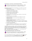
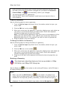
6. To change the geometry shape of the layer, select an option from the
Geometry Shape drop-down list.
• Planar (default)-This geometry shape is best for medium or large-
scale mapping and is a simpler, and subsequently faster when
performing spatial analysis, way of storing spatial data. It does not
take the curvature of the earth into account, so line and polygon
geometries that span long distances do not appear curved on the map.
• Spherical-This geometry shape is best for large-scale mapping and is
more complex than Planar. As a result, spatial analysis operations may
take more time. It does take the curvature of the earth into account,
so line and polygon geometries that span long distances appear curved
on the map.
Note Changing a layer to or from the Spherical Geometry type may
lock up the database while you perform the operation.
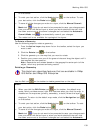
• Topological (line layers only)-This geometry shape is used to store
connections between nodes of intersecting lines. Once two or more
nodes are connected, any repositioning of that node automatically
repositions all the line segments that share that node. The Topological
geometry shape is stored as a Planar type.
• Unregistered (.dxf, .dwg, and .dwf layers only)-This geometry shape
is used for imported layers (dxf, .dwg, .dwf) that have no spatial
reference on the Earth. Until these layers are registered with the
Register tool, you cannot perform spatial analysis. Once registration is
completed for a layer, it is automatically assigned the Planar type.
• Geocode (geocoded la
yers only)-This geometry shape is used for
geocoded point layers and has special attribute properties. When you