


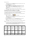

XMap User Guide
42
• Click Use Defaults to change the map feature settings to the default
preferences.
• The options available depend on the datasets you are using.
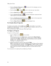
To Select Basic Map Feature Preferences
Use the following steps to change the basic map feature preferences. Changes made
to the map view display almost immediately after selection.
1. Click the Options button
on the toolbar.
OR
Click the arrow next to the Options toolbar button to open the menu. Then,
click Options to open the dialog box.
2. Click the Map Features tab.
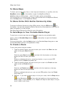
3. Select the check box next to the map features you want to display on the
map.
OR
Clear the check box next to the map features you want to hide on the map.
• Shaded Relief—Shaded relief becomes visible at data zoom level 6-0
or greater. It simulates the effect of sun shining on terrain features
and casting shadows, providing greater depth perception of the image.
Lighter shades of gray indicate gentle terrain and darker shades
indicate steep terrain. Using shaded relief may slow down the draw
time of the map screen as you pan.
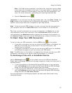
• Contours—Contour lines are available at data zoom level 6-0 or
greater. Contour lines show the elevation of the land in feet or meters.
The closer the contour lines, the greater the slope. The distance
between the lines is the contour interval, which is indicated in the
Control Panel (distance units are controlled in the Options dialog box).
• Land Cover—Land cover colors are available at all data zoom levels.
Colors indicate vegetation and land cover areas on the map such as
rock and sand, forests, transitional areas, and wetlands.
• Grids—The Grids option can be used to identify coordinate points on
the map. Grid lines automatically adjust for the data zoom level of
your map.
• Parks or Reserves—Parks and Reserves are available at data zoom
level 7-0 or greater and include areas such as parks, preserves,
recreational area and public forests.
• Publicly Managed Lands—Publicly Managed Lands are only available
when the Bureau of Land Management (BLM) dataset is downloaded
and installed. The feature includes areas such as lands managed
through the Bureau of Land Management and displays at all data zoom
levels.
• Game Management Districts—Wildlife Management Units are only
available when the Wildlife Management Units (WMU) dataset is
downloaded and installed. The feature includes areas of managed
wildlife and game and displays at data zoom level 6-0 or greater.
• USGS Quadrangle Coverage—The USGS 7.5 minute quadrangle
coverage is indicated by red lines. These display at data zoom level 8-
0 or greater. Quadrangle names display at data zoom level 9-0 and
higher. To view quad info such as Orig Date and Quad Order ID