


2 - NAV PAGES
56
190-00357-00 Rev E
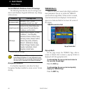
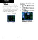
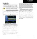
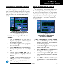
Each satellite has a 30-second data transmission
that must be collected (hollow signal strength bar)
before the satellite may be used for navigation (solid
signal strength bar). Once the GPS receiver has deter-
mined your position, the 500W-series unit indicates
your position, altitude, track and ground speed. The
GPS receiver status field also displays the following
messages under the appropriate conditions:
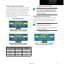
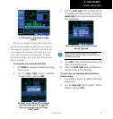
•Searching Sky —
The GPS receiver is searching the sky for ANY vis-
ible satellites. You are also informed of this status
with a “Searching the Sky” message.
•AcquiringSat —
The GPS receiver is acquiring satellites for naviga-
tion. In this mode, the receiver uses satellite orbital
data (collected continuously from the satellites) and
last known position to determine the satellites that
should be in view.
•3DNavigation —
TheGPSreceiverisin3Dnavigationmodeand
computes altitude using satellite data.
•3DDifferentialNavigation—TheGPSreceiveris
in3Dnavigationmodeanddifferentialcorrections
are being used.
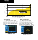
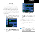
The Satellite Status Page also indicates the accu-
racy of the position fix, using Horizontal Figure of
Merit (HFOM),VerticalFigureofMerit(VFOM), and
Estimated Position Uncertainty (EPU). HFOM and
VFOMrepresentthe95%condencelevelsinhori-
zontal and vertical accuracy. The lowest numbers are
the best accuracy and the highest numbers are worse.
EPU is the horizontal position error estimated by the
FaultDetectionandExclusion(FDE) algorithm, in feet
or meters.
NOTE Operating outside of an SBAS service area
with SBAS enabled may cause elevated EPU values to
be displayed on the satellite status page. Regardless of
the EPU value displayed, the INTEG annunciation is the
controlling indication for determining the integrity of
the GPS navigation solution.
Dead Reckoning