


6 - WPT PAGES
124
190-00357-00 Rev E
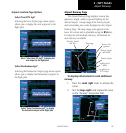
Airport Location
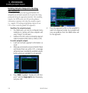
Airport Location Page
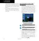
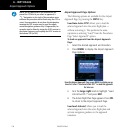
The Airport Location Page displays the latitude,
longitude, and elevation of the selected airport. The
Airport Location Page also displays facility name and
location, as well as fuel availability, best available
instrument approach, radar coverage and airspace type.
Identifier, Symbol
and Type
Latitude/Longitude
Position
Facility Name and
Location (City)
Field Elevation
Available Fuels
Radar Availability
Airspace Type
First Page in
WPT Group
Best Available Approach
and Radar Coverage
The following descriptions and abbreviations are
used:
•Type— Usagetype:Public,Military,
Heliport, or Private
•Position— Latitude/Longitude(degrees/min-
utes or degrees/minutes/seconds),
MGRS or UTM/UPS
•Elevation— Infeetormeters
•Fuel— Forpublic-useairports,the
available fuel type(s) are: Avgas
(80-87/100LL/100-130/Mogas),
Jet, or None
•Approach—
Best available approach: ILS, MLS,
LOC,LDA,SDF,GPS,VOR,RNAV
(“RNV”),LORAN(“LOR”),NDB,
TACAN (“TCN”), Helicopter
(“HEL”),orVFR
•Radar— Radarcoverage:YesorNo
•Airspace— Controlenvironment:ClassC,
CTA, TMA, TRSA, Class B or
none
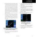
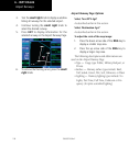
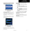
Airport Location Page indicating radar
coverage and airspace type. The Airport Loca-
tion Page also indicates the best available
approach for the selected airport. To see
additional approach information, select the
Airport Approach Page.
NOTE: Upon active navigation changes, the active
destination airport is used as the default airport on the
WPT pages. Manual selection of the destination airport
is available from the page menu.