


2 - NAV PAGES
55
190-00357-00 Rev E
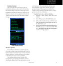
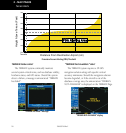
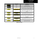
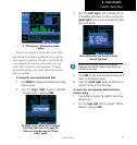
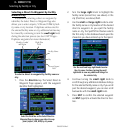
Satellite Status Page
As satellites are received, the status changes
to “3D Navigation”. 3D Navigation includes
altitude.
The sky view display at the top left corner of the
page shows the satellites currently in view as well as
their respective positions. The outer circle of the sky
view represents the horizon (with north at the top
of the circle); the inner circle represents 45° above
the horizon and the center point shows the position
directly overhead.
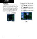
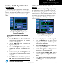
To change the user-selectable data field:
1. Press MENU to display the Satellite Status Page
Options menu.
2. Turn the large right knob to highlight
“Change Fields?” and press ENT.
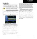
By default, current altitude (ALT) is displayed
in the lower right corner of the page. This
field is user selectable using the “Change
Fields?” option.
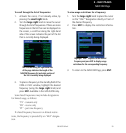
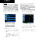
3. Turn the small right knob to display the list
of available data items. Continue turning the
small right knob to select the desired data
item from the list.
Select a different data type from the list using
the small right knob.
NOTE: Do not rely solely on MSA as an absolute
measure of safe altitude. Consult current charts and
NOTAMs for your area.
5. Press ENT to select the desired data item and
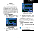
return to the position page.
6. Press the small right knob momentarily to
remove the cursor from the page.
To restore the user-selectable data field factory
default setting:
1. Press MENU to display the Satellite Status Page
Options menu.
2.
Turn
the large right knob to highlight “Restore
Defaults?” and press ENT.