


2 - NAV PAGES
48
190-00357-00 Rev E
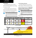
Terrain/Obstacle Database Areas of Coverage
The following describes the area of coverage avail-
able in each database. Regional definitions may change
without notice.
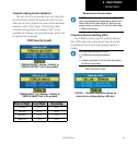
Database Coverage Area
Worldwide (WW)
Latitudes: N 75° to S 60°
Longitudes: W 180° to E 180°
United States (US)
Limited to the United States plus
some areas of Canada, Mexico,
Caribbean, and the Pacific.
US/Europe
Alaska, Austria, Belgium, Canada*,
Caribbean*, Czech Republic,
Denmark, Estonia, Finland, France,
Germany, Greece, Hawaii, Iceland,
Ireland, Italy, Latvia, Lithuania,
Mexico*, Netherlands, Norway,
Poland, Portugal, Slovakia, Spain,
Sweden, Switzerland, United
Kingdom, United States
* Indicates partial coverage
CAUTION: Obstacles 200 feet and higher are included
in the Obstacle Database. It is very important to note
that not all obstacles are necessarily charted and there-
fore may not be contained in the Obstacle Database.
Navigation Database
It is therefore important to also have the latest
NavigationDatabaseinstalledtoensurecorrectTerrain
alerting.
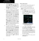
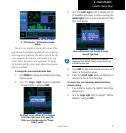
TERRAIN Alerts
TERRAIN alerts are issued when flight conditions
meet parameters that are set within the TERRAIN
system software algorithms. When an alert is issued,
visual annunciations are displayed. Annunciations
appear in a dedicated field in the lower left corner of
the display.
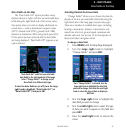
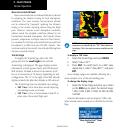
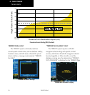
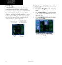
Pop-up Terrain Alert
TERRAIN Annunciation Field
Pop-up Alerts
On any page except the TERRAIN Page, when a
terrain or obstacle alert is issued, a pop-up window is
displayed with the appropriate alert.
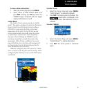
To acknowledge the pop-up alert and return to
the currently viewed page:
Press the CLR key.
To acknowledge the pop-up alert and quickly
display the TERRAIN Page:
Press the ENT key.
Terrain Alerts