


2 - NAV PAGES
44
190-00357-00 Rev E
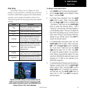
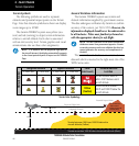
Baro-Corrected Altitude
Baro-corrected altitude (or indicated altitude) is derived
by adjusting the altimeter setting for local atmospheric
conditions. The most accurate baro-corrected altitude
can be achieved by frequently updating the altimeter
setting to the nearest reporting station along the flight
path. However, because actual atmosphere conditions
seldom match the standard conditions defined by the
International Standard Atmosphere (ISA) model (where
pressure, temperature, and lapse rates have fixed values),
it is common for the baro-corrected altitude (as read from
the altimeter) to differ from the GPS-MSL altitude. This
variation results in the aircraft’s true altitude differing from
the baro-corrected altitude.
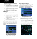
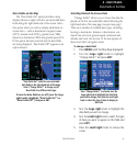
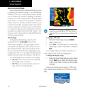
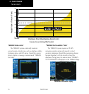
Terrain Page
TodisplaytheTerrainPage,selecttheNAV
group and turn the small right knob until the
Terrain Page is displayed. The page displays terrain
information, aircraft ground track, and GPS-derived
MSL altitude. Altitude is shown in increments of 20
feet or in increments of 10 meters, depending on unit
configuration. The “G” to the right of the MSL altitude
display reminds the pilot that altitude is GPS-derived.
The Terrain Page has two selectable view settings:
• 360˚ View—Viewfromaboveaircraftdepicting
surrounding terrain on all sides
• 120˚ View—Viewofterrainaheadofand60˚to
either side of the aircraft flight path
TERRAIN Page with 360° View
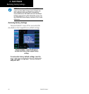
NOTE: The Terrain Page gives a “Track Up” display
orientation, as indicated by the “TRK” label shown on
the display. This is the only orientation available on this
page.
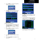
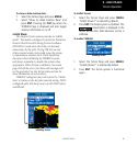
To display a 120˚ view:
1. Select the Terrain Page and press MENU.
2. Select “View 120˚?”.
3. Press ENT. To switch back to a 360˚ view,
repeat step 1, select “View 360˚?”, and press
ENT.
Seven display ranges are available, allowing for a
more complete view of the surrounding area.
To change the display range:
1. Select the Terrain Page and press up or down
on the RNG key to select the desired range:
1 NM, 2 NM, 5 NM, 10 NM, 25 NM, 50 NM,
100 NM.
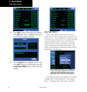
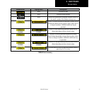
Aviationinformationsuchasairports,VORs,and
other navaids can be turned on or off from the Terrain
Page.
“Show Aviation Data?” Menu
Selection
Terrain Operation