


2 - NAV PAGES
46
190-00357-00 Rev E
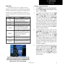
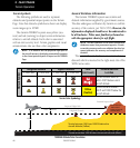
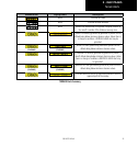
Terrain Symbols
The following symbols are used to represent
obstacles and potential impact points on the Terrain
Page. Note that obstacle symbols are shown on display
zoom ranges up to 10 NM:
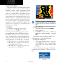
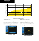
The Garmin TERRAIN system uses yellow (cau-
tion) and red (warning) to depict terrain information
relative to aircraft altitude. Each color is associated
with an alert severity level. Terrain graphics and visual
annunciations also use these color assignments.
NOTE: If an obstacle and the projected flight path of
the aircraft intersect, the display automatically zooms in
to the closest potential point of impact on the TERRAIN
Page.
General Database Information
The Garmin TERRAIN system uses terrain and
obstacle information supplied by government sources.
The data undergoes verification by Garmin to confirm
accuracy of the content, per TSO-C151b. However, the
information displayed should never be understood to
be all-inclusive. Pilots must familiarize themselves
with the appropriate charts for safe flight.
NOTE: The data contained in the terrain and obstacle
databases comes from government agencies. Garmin
accurately processes and cross-validates the data, but
cannot guarantee the accuracy and completeness of
the data.
The terrain/obstacle databases are contained on a
datacard which is inserted in the right-most slot of the
500W Series units.
Terrain Operation
Potential Impact Point
Unlighted Obstacle
Projected Flight Path
£äääÊvÌÊ
£ääÊvÌÊ/ÀiÃ`Ê
4ERRAINMORETHANFTBELOWTHEAIRCRAFTALTITUDE"LACK
4ERRAINBETWEENFTANDFTBELOWTHE
AIRCRAFTALTITUDE9ELLOW
4ERRAINABOVEOR
WITHINFT
BELOWTHEAIRCRAFT
ALTITUDE2ED
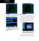
TERRAIN Altitude/Color Correlation
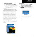
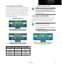
Obstacle Symbol
Unlighted Obstacle Lighted Obstacle Color
(Alert Level)
TERRAIN/Obstacle
Location
< 1000’ AGL > 1000’ AGL < 1000’ AGL > 1000’ AGL
Red
(Warning)
Terrain/Obstacle above or
within 100 ft below current
aircraft altitude
Yellow
(Caution)
Terrain/Obstacle between
100 ft and 1000 ft below the
aircraft altitude
Terrain Color Symbology