


5 - PROCEDURES
111
190-00357-00 Rev E
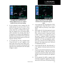
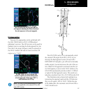
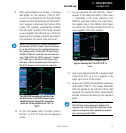
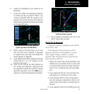
9. After approximately one minute, a message
will appear for turn advisory (“Left to 255°
in x sec”) to intercept the ILS. The GNS 530W
sequences to the inbound leg and “Left to 210°
now” appears in the lower right corner of the
screen. CDI coupling automatically switches
from the “GPS” receiver to the “VLOC” receiver
as you complete the inbound turn. (If the ILS
frequency has not been activated, per step #4,
this automatic CDI switch does not occur.)
NOTE: From this point on, primary navigation is
provided by the VLOC receiver. You may continue
to use the GPS receiver for supplemental naviga-
tion guidance only. If automatic CDI switching is
disabled (“Manual” selected), the reminder mes-
sage “Select VLOC on CDI for approach” appears
at 2.0 NM prior to the FAF. In this instance, you
must press CDI to manually switch CDI output to
the VLOC receiver and continue the approach.
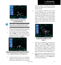
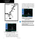
The GNS 530W automatically switches from
the GPS receiver to the VLOC receiver as you
complete the turn inbound. The annunciator
above the CDI key switches from “GPS” to
“VLOC”.
10. As the CDI needle starts to center, make a
left turn to 210° to track the ILS approach
course.
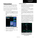
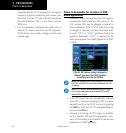
11. As you approach the FAF (SHUTR), “LNAV”
appears in the lower left corner of the screen
— indicating a CDI scale transition from
TERM to approach scaling. This scale transi-
tion applies only to the Default NAV Page’s
on-screen CDI, since the external CDI or HSI is
now coupled to the VLOC receiver.
As you approach the FAF, a waypoint alert
appears indicating that “Next DTK 210
°
in
x sec. .
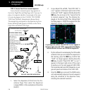
12. Also as you approach SHUTR, a waypoint alert
(“Next DTK 210° in x sec”) appears in the
lower right corner of the screen.
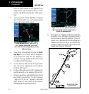
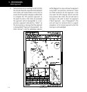
13. As you cross SHUTR, the destination sequences
to the MAP (“RW21”, the runway threshold).
With the needle on the external CDI (or HSI)
centered, fly toward the MAP, observing the
altitude minimums dictated by the approach
plate.
NOTE: When viewing the Map Page, you’ll note
that the final course segment is displayed in
magenta (the active leg of the flight plan always
appears in magenta) and a dashed line extends
the course beyond the MAP.
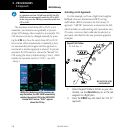
ILS Approach
GNS 530W only