


AV8OR User’s Guide Aviation Mode Operation
VFR Moving Map Function
Pub. No D200803000008 Page 3-24 Revision July 2008.
© Honeywell International Inc. Do not copy without express permission of
Honeywell.
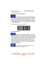
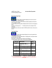
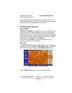
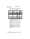
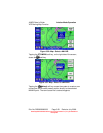
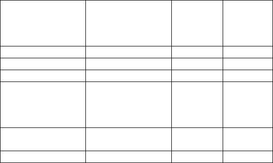
o A 0.5 Nm radius circle around each is colored
according to the height of the obstacle relative to the
aircraft, as shown in the following table.
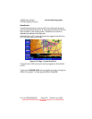
Relative Terrain
Altitude (feet)
Relative
Obstacle
Altitude (feet)
Color Dither
Pattern
Percent
Filled
>= +250 >= -250 Red 50%
-250 to +249 -750 to –251 Yellow 50%
-750 to –251 -1250 to –751 Yellow 25%
-1250 to –751 -17500 to –1251 Dark
Green
/Dark
Yellow
50%
-2000 to –1251 < -2000 to -1751 Dark
Green
100%
< -2000 < -2000 Black 100%
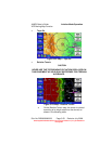
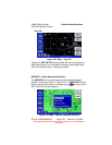
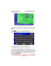
o At ranges of 200 Nm and less, areas not covered by
the terrain database are displayed using a 50 % red
dithered pattern.
o The Relative Terrain Map is rotated and scaled
consistent with the current map location, orientation
and range.
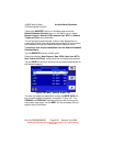
o When terrain data is scaled for display, the highest
elevation is used for each location to determine its
color.
o The 0.5 Nm radius circles around obstacles are
displayed only if their radii after scaling are large
enough to be shown.
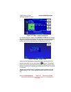
o If altitude information is not available then a warning
message is displayed on the map image with the text
“No Altitude Available. Relative Terrain Not
Displayed.”