


AV8OR User’s Guide Aviation Mode Operation
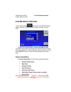
System Setup Function
Pub. No D200803000008 Page 3-76 Revision July 2008.
© Honeywell International Inc. Do not copy without express permission of
Honeywell.
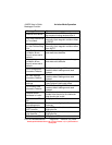
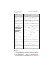
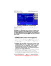
menu. Tap the RESET VALUES soft key to set all options to their
factory initial settings except Minimum Elevation when it is currently
set to a valid value.
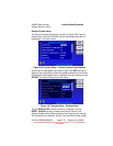
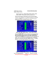
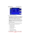
• Orientation: Sets the Map Mode presentation to either a
TRACK UP or NORTH UP orientation.
• Extended Track Line: Turns the extended track line ON or
OFF. The extended track line is drawn ahead of the aircrafts
present position in the direction of the present track.
• Range Rings On Map: Controls the display of the range rings
shown around the aircraft. OFF removes the rings. OUTER
RING shows only the outer ring. OUTER AND INNER RING
shows both rings.
• Airport Label Format: Labels airports in Map Mode either
with their ICAO CODE, their FULL NAME (given airport name)
or CITY NAME (local city name).
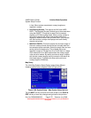
• Auto Zoom: Turns the auto zoom function ON or OFF. When
flying the last leg of a Flight Plan or when flying a Direct To,
the system automatically zooms to a screen range that keeps
the destination WPT within the display area. The system
continues to zoom in to the lowest zoom level. When the
lowest zoom has been reached and the aircraft begins to fly
away from the destination WPT, then the system zooms out
automatically to keep the WPT within the display area. When
auto zoom is in operation AUTO (Automatic) is shown in the
RNG (Range) display field. Pushing either the ZOOM IN or
ZOOM OUT soft key cancels the auto zoom capability. Auto
zoom is re-activated in this menu.
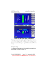
• Minimum Elevation: Controls the high definition terrain
contours minimum level elevation. When altitude units are set
to meters the options are: SEA LEVEL, 300M, 500M, 900M
and 1200M. When altitude units are set to feet the options are:
1000ft, 2000ft, 3000ft and 4000ft.
• Maximum Elevation: Controls the high definition terrain
contours maximum level elevation. The options are: 500M,
750M, 1000M, 1250M, 1500M, 1750M, 2000M, 2250M,
2500M, 3000M and MAXIMUM. When altitude units is set to