


1-47
Rev 4 Apr/2004 KMD 250 Pilot's Guide
Section 1
Basic Operation
ENTERING A USER AIRPORT
A User Airport is actually a User Waypoint to which additional airport
information may be added.
The first User Airport Edit display is used in the same way as the User
Waypoint Edit display as previously discussed. The following illustration
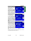
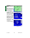
describes the second User Airport Edit display.
After entering the identifier,
remarks and position informa-
tion as discussed in steps 1
through 19 of Entering A User
Waypoint, perform the fol-
lowing to enter additional infor-
mation airport information.
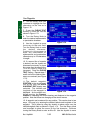
1. Use the Joystick to place
the cursor over the TYPE field
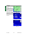
as shown in Figure 1-81.
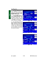
User Waypoints
Figure 1-81
1 Waypoint Identifier - Editable on the first User Airport Edit display.
2 Runway Orientation - Selectable from 01/19 through 18/36.
3 Runway Surface Type - Hard or Soft can be selected.
4 Comm Frequecy Type - One of 33 abbreviations may be selected in each of two fields.
See Appendix A for abbreviations.
5 Comm Frequecies - Any valid 8.33 kHz or 25 kHz communication frequency in each of two
fields.
6 Runway Elevation - The runway elevation can be entered from -2000 to 30,000 ft.
7 Runway Length - The length of the runway can be entered from 0 to 20,000 ft.
8 Airport Icon - Airport symbol that will be displayed on the map. If the runway Surface is
set to Soft, the symbol will be of the type for a soft runway with no IFR approach. If the
runway Surface is set to Hard, the symbol will be of the type for a hard runway with no IFR
approach.
9 Waypoint Type - This field reflects Waypoint or Airport depending on the desired waypoint
definition. Selectable on the first User Airport Edit display.
6
3
4
5
7
8
9
1
2