


1-2
Rev 4 Aug/2007
KMD 250 Pilot's Guide
Section 1
Basic Operation
Introduction
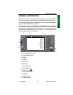
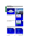
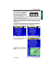
The KMD 250 performs the following functions:
• Configurable Moving Map Display with aeronautical and cartographic
database
• User Entered Waypoints
• Flight Planning and Direct-To
• Terrain awareness display (Terrain color coded by relative altitude)
• FIS weather data display and overlays
• TCAS/TAS/TIS traffic display and overlay
• L-3 WX-500 Stormscope® display and overlay
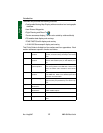
This Pilot’s Guide is divided into five sections and four appendices. Each
section addresses a specific function as follows:
Section 1 Basic KMD 250
Operation
Explains the use of the Map Display, Flight Planning,
Joystick, Functions Keys, Softkeys and Rotary
Knob.
Section 2 FIS VDL or XM
Operation
Explains the operation of the Flight Information
Services VHF Datalink (VDL) or XM weather prod-
ucts.
Section 3 Traffic Avoidance
System Operation
Explains operation of TCAS I, TCAS II and TIS sys-
tems as they pertain to the KMD 250. Refer to the
TCAS I or TCAS II user’s manual for more informa-
tion.
Section 4 WX-500 Stormscope®
Operation
Explains operation of the Stormscope® as it pertains
to the KMD 250. Refer to the Stormscope® user’s
manual for more information.
Section 5 System Messages Explains accessing and the meaning of system mes-
sages that may be presented by the various sys-
tems.
Appendix A Definitions, Acronyms,
Abbreviations
Explains various terms and abbreviations.
Appendix B Common Weather
Abbreviations
Explains weather abbreviations commonly seen in
aviation weather reports.
Appendix C GPS Primer An overview of how GPS works.
Appendix D Navigation Terms Definitions and examples of common navigation
terms.