


2-78
Section 2
FIS Operation
Understanding Weather Reports
KMD 250 Pilot's Guide
Rev 4 Aug/2007
TOPS ABV (above) FL450 (flight level 4-5-0). WIND GUSTS TO
60KT (knots) RPRTD (reported). TORNADOES…HAIL TO 2 IN
(inches in diameter)…WIND GUSTS TO 65 KT (knots) PSBL (pos-
sible).
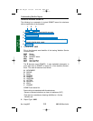
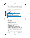
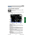
UNDERSTANDING ALERT WEATHER WATCHES (AWW)
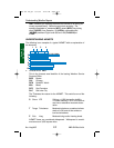
The following is an example of a typical Alert Weather Watch with an
explanation of the elements.
1. Station Identifier: SPC
SPC is the station identifier for the Storm Prediction Center in
Norman, Oklahoma.
AWWs are issued for:
Tornado
Damaging winds or winds > 58 knots
Hail ≥ 3/4 inch in diameter.
2. Report Type: AWW
AWW indicates this is an Alert Weather Watch.
3. Date and Time Issued: 162236.
16 indicates the 16th day of the month. 2236 indicates UTC.
4. WW 1162 is the identifying number of the Alert Weather Watch.
Numbering begins yearly at 0000.
5. This line indicates the type of weather and the affected areas.
SEVERE TSTM (severe thunderstorm) for MS (Mississippi) AL
(Alabama) FL (Florida) AND ADJ CSTL WTRS (adjacent coastal
waters).
6. This line indicates that the watch is valid from 162300Z - 170400Z
SPC AWW 162236
WW 1162 SEVERE TSTM MS AL FL AND ADJ CSTL WTRS
162300Z - 170400Z
AXIS..75 STATUTE MILES NORTH AND SOUTH OF LINE..
45SW MOB/MOBILE AL/ - 30SSE DHN/DOTHAN AL/
..AVIATION COORDS.. 65NM N/S /37SW MOB - 51WNW TLH/
HAIL SURFACE AND ALOFT..1 1/4 INCHES. WIND GUSTS..60
KNOTS. MAX TOPS TO 400. MEAN WIND VECTOR 23035.
13
4
2
6
7
8
5
9
KMD 250 FIS_R4 8/13/07 10:07 AM Page 2-78