B-3
Rev 2 Apr/2004 KMD 250 Pilot's Guide
Appendix B
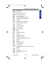
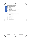
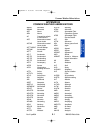
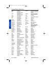
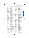
Wx Abbreviations
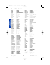
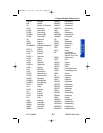
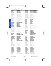
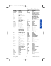
Common Weather Abbreviations
BLKTS Blankets
BLO Below or below
clouds
BLW Below
BLZD Blizzard
BN Blowing sand
BND Bound
BNDRY Boundary
BNDRYS Boundaries
BNTH Beneath
BOOTHEEL Bootheel
BR Branch or mist
(METAR, used only
for visibility between
5/8 and 6 miles)
BRF Brief
BRG Branching
BRK Break
BRKG Breaking
BRKHIC Breaks in higher
clouds
BRKS Breaks
BRKSHR Berkshire
BRKSHRS Berkshires
BRM Barometer
BRN Bulk Richardson
Number
BRS Branches
BS Blowing snow
BTWN Between
BWER Bounded weak
echo region
BYD Beyond
C Celsius
CA California or cloud-
to-air lightning in
PIREPs
CAA Cold air advection
CAPE Convective available
potential energy
CARIB Caribbean
CAS Committee for
Aviation Services
CASCDS Cascades
CAT Clear air turbulence
CAVOK Ceiling and visibility
OK
CAVU Ceiling and visibility
unlimited
CB Cumulonimbus
CBMAM Cumulonimbus
Mammatus clouds
CC Cirrocumulus
CCCC Generic WMO format
code group for a
four-letter location
identifier
CCL Convective conden-
sation level
CCLDS Clear of clouds
CCLKWS Counterclockwise
CCSL Cirrocumulus
standing lenticular
CCx Code used in the
WMO abbreviated
heading to indicate
a corrected forecast,
where x is the letter
A through X
CDFNT Cold front
CDFNTL Cold frontal
CFP Cold front passage
CG Cloud to ground
(lightning)
CHC Chance
CHCS Chances
CHG Change
CHGD Changed
CHGG Changing
CHGS Changes
CHI Cloud-Height
indicator
CHINO Sky condition at
secondary location
not available
CHOP Turbulence type
characterized by
rapid, rhythmic jolts
CHSPK Chesapeake
CI Cirrus
Appendix B 8/13/07 10:02 AM Page B-3


