2-65
Rev 4 Aug/2007
KMD 250 Pilot's Guide
Section 2
FIS Operation
UNDERSTANDING TEXTUAL AVIATION
WEATHER REPORTS
UNDERSTANDING METARS
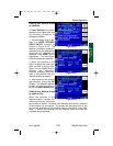
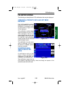
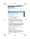
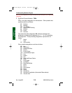
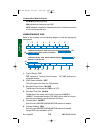
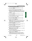
Refer to the numbers on the following diagram to find the appropriate
descriptions.
1. Type of Report: METAR (SPECI will be seen here if this is a Special
Weather Report)
2. ICAO Station Identifier: KPIT
This is the location for which the METAR pertains.
3. Date and Time of Issue: 201955Z
The 20th day of the month at 1955Zulu or UTC.
4. AUTO indicates the reporting station is an automated station. If the
reporting station is a manned station this element will be omitted.
Also, if a report from an automated station is modified by a person
this element will be omitted. “COR” indicates a corrected report.
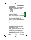
5. Wind: 22015G25KT
220 is the 3 digit true direction to the nearest 10°. Airport advisory
service, ATIS and ATC towers report wind direction as magnetic.
“VRB” in this place indicates variable winds less than or equal to 6
knots. If wind direction is varying more than 60° with speeds over 6
knots, an entry similar to “180V260” will be displayed in this place.
This example actually shows wind direction varying by 80°.
15 is the 2 or 3 digit wind speed (in knots).
25 is the 2 or 3 digit wind gust speed in knots (KT) because it follows a
G (Gust).
6. Visibility: 3/4SM R28R/2600FT
3/4 indicates 3/4 statute mile (SM) visibility.
Runway Visual Range (RVR) for R28R (runway 28 right) is 2600 feet
(2600FT). An “M” in this distance number indicates visibility is less
than the lowest reportable sensor value. A “P” indicates visibility is
greater than the highest reportable sensor value.
Understanding Weather Reports
METAR KPIT 201955Z AUTO 22015G25KT 3/4SM R28R/2600FT TSRA OVC010CB
18/16 A2992 RMK SLPO13 T01760158 PK WND 22030/15
13452678
910 11
KMD 250 FIS_R4 8/13/07 10:07 AM Page 2-65


