


2-74
Section 2
FIS Operation
Understanding Weather Reports
KMD 250 Pilot's Guide
Rev 4 Aug/2007
UNDERSTANDING SIGMETS
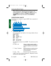
The following is an example of a typical SIGMET issued for turbulence
with an explanation of the elements.
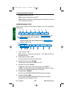
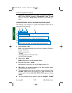
1. Forecast Area: CHIR
This is the forecast area identifier of the issuing Weather Service
Forecast Office.
BOS Boston
CHI Chicago
DFW Dallas/Ft. Worth
MIA Miami
SFO San Francisco
SLC Salt Lake City
The R denotes report ROMEO. A new alphabetic designator is
given each time a SIGMET is issued for a new weather phenom-
enon. The order of issuance is as follows:
N NOVEMBER
O OSCAR
P PAPA
Q QUEBEC
R ROMEO
U UNIFORM
V VICTOR
W WHISKEY
X XRAY
Y YANKEE
SIGMETs are issued for:
Severe icing not associated with thunderstorms
Severe or extreme turbulence or clear air turbulence (CAT)
Dust storms or sandstorms lowering visibilities to < 3 miles
Volcanic ash
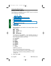
2. Report Type: UWS
CHIR UWS 041430
SIGMET ROMEO 1 VALID UNTIL 041830
KY TN WV VA OH
FROM CVG TO EKN TO PSK TO VXV TO CVG
OCNL SEV TURB BTN 300 AND 360. RPRTD BY AIRCRAFT.
CONDS CONTG BYD 1830Z.
SLM/GTB
13
4
5
2
6
7
8
KMD 250 FIS_R4 8/13/07 10:07 AM Page 2-74