


2-15
KMD 250 Pilot's Guide
Section 2
FIS Operation
Rev 4 Aug/2007
10. Echoes from migrating birds, bats, and insects will be displayed as
circular patterns of level 1 reflectivity centered near NEXRAD sites.
11. Significant variation in humidity with altitude can cause reflections
from the Earth's surface. These reflections are also displayed as large
circular or oval areas of uniform low intensity.
12. Differences will be noted between the base reflectivity (VDL) and
composite (XM) products. The base reflectivity product displays the
lower extent of cloud masses, so the extent of water droplets appears to
be less. The composite product provides more airborne water reflection
seen at higher angles as viewed from the NEXRAD ground sites, so
higher level features of the convective activity will be given. For example,
the “blowout” portion of thunderstorms (the anvil portion) containing high
altitude ice particles is often depicted as light precipitation and might be
confused for lower altitude light precipitation. Either base or composite
product provides an accurate, but somewhat time delayed depiction of
high levels of precipitation for fully developed or late stage thunder-
storms.
NEXRAD LIMITATIONS
The following are limitations on the use of NEXRAD data:
1. NEXRAD does not provide sufficient information to determine cloud
layers or precipitation characteristics (frozen vs. liquid, hail vs. rain, etc.),
nor does it provide information on turbulence, only the amount of
reflected energy from the precipitation.
2. The displayed NEXRAD product does not provide sufficient detail to
infer future weather trends. Due to delays involved in product creation
and transmittal, the pilot should always review the age bar to determine
information currency.
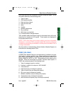
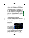
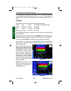
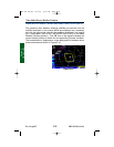
3. Due to NEXRAD site loca-
tion limitations, terrestrial block-
ages and outages, NEXRAD
coverage gaps exist.
Coverage gaps are displayed
as a cross hatched pattern as
shown in Figure 2-2. Lack of
reflectivity in a coverage gap
area should not be construed
as a lack of precipitation.
Coverage gaps are portrayed
identically on either VDL or XM.
4. The resolution of NEXRAD
VDL data is 4 kilometers (km). Thus, when zoomed in on the display,
each square block is 4 km in diameter. The intensity level reflected by
the square will be the highest level sampled within the 4 km area.
Figure 2-2
Value Added Service Weather Products
Coverage Gap
KMD 250 FIS_R4 8/13/07 10:07 AM Page 2-15