


B-13
Rev 2 Apr/2004 KMD 250 Pilot's Guide
Appendix B
Wx Abbreviations
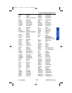
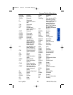
OTRW Otherwise
OUTFLO Outflow
OV Over
OVC Overcast
OVHD Overhead
OVNGT Overnight
OVR Over
OVRN Overrun
OVRNG Overrunning
OVTK Overtake
OVTKG Overtaking
OVTKS Overtakes
P Higher than greatest
sensor value
P6SM Visibility forecast to
be greater than 6
statute miles
PA Pennsylvania
PAC Pacific
PATWAS Pilot's automatic
telephone weather
answering service
PBL Planetary boundary
layer
PCPN Precipitation
PD Period
PDS Periods
PDMT Predominant
PE Ice pellets
PEN Peninsula
PERM Permanent
PGTSND Puget Sound
PHYS Physical
PIBAL Pilot balloon obser-
vation
PIREP Pilot weather report
PK WND Peak wind
PL Ice pellets
PLNS Plains
PLS Please
PLTO Plateau
PM Postmeridian
PNHDL Panhandle
PNO Precipitation amount
not available
PO Dust/ sand swirls
POS Positive
POSLY Positively
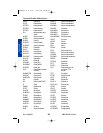
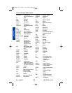
PPINA Radar weather
report not available
PPINE Radar weather
report no echoes
observed
PPSN Present position
PR Partial
PRBL Probable
PRBLY Probably
PRBLTY Probability
PRECD Precede
PRECDD Preceded
PRECDG Preceding
PRECDS Precedes
PRES Pressure
PRESFR Pressure falling
rapidly
PRESRR Pressure rising
rapidly
PRFG Partial fog
PRIM Primary
PRIN Principal
PRIND Present indications
are...
PRJMP Pressure jump
PROB Probability
PROBC C Forecaster’s
assessment of the
probability of occur-
rence of a thunder-
storm or precipita-
tion event, along
with associated
weather elements
(wind, visibility,
and/or sky condi-
tion) whose occur-
rences are directly
related to, and con-
temporaneous with,
the thunderstorm or
precipitation event
Common Weather Abbreviations
Appendix B 8/13/07 10:02 AM Page B-13