


3-4
Garmin G500 Pilot’s Guide
190-01102-02 Rev. B
Foreword
Sec 1
System
Sec 2
PFD
Sec 3
MFD
Sec 4
Hazard
Avoidance
Sec 5
Additional
Features
Sec 6
Annun.
& Alerts
Sec 7
Symbols
Sec 8
GlossaryAppendix A
Appendix B
Index
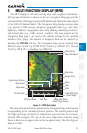
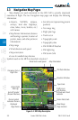
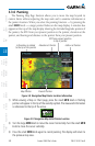
3.3 Navigation Map Pages
Map displays are used extensively in the GDU 620 to provide situational
awareness in flight. The two Navigation map pages can display the following
information:
•Airports, NAVAIDs, airspace,
airways, land data (highways,
cities, lakes, rivers, borders, etc.)
with names
•MapPointer information (distance
and bearing to pointer, location of
pointer, name, and other pertinent
information)
•Maprange
•Wind direction and speed
•Maporientation
•Iconsforenabledmapfeatures
•Aircrafticon(representingpresent
position)
•Navrange ring
•Flightplan legs
•Trackvector
•Topographyscale
•Topographydata
•XMNEXRADWeather
•XMLightning
•XMStormCells
Symbols used on the MFD are detailed in Section 7.
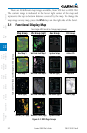
Wind Vector and Speed Map Orientation
TFR Data Window
Elevation Window
Topo Scale
Terrain Data Scale
Page Location
Map Range
Traffic Icons
with Relative
Altitude and Trend
Indicator
Aircraft Symbol
(Present Position)
Active Flight
Plan Leg
Procedure Turn in
Flight Plan
Page Name
Terrain Symbol
Indicates Terrain is
Displayed
Figure 3-4 MFD Map Description