


4-62
Garmin G500 Pilot’s Guide
190-01102-02 Rev. B
Foreword
Sec 1
System
Sec 2
PFD
Sec 3
MFD
Sec 4
Hazard
Avoidance
Sec 5
Additional
Features
Sec 6
Annun.
& Alerts
Sec 7
Symbols
Sec 8
GlossaryAppendix A
Appendix B
Index
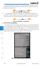
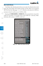
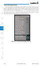
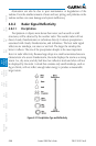
County Data Viewing Range
The County Data Viewing Range option allows you to select the map range
where at and below that value County weather products will be shown on the
selected MFD Wx Data Link Map pages (1, 2, or 3). When Off is selected, County
Data will not be shown. In the figure below where 100 NM is selected, County
data will be shown at map ranges of 100 NM and lower.
Figure 4-54 County Data Viewing Range Selection