


4-54
Garmin G500 Pilot’s Guide
190-01102-02 Rev. B
Foreword
Sec 1
System
Sec 2
PFD
Sec 3
MFD
Sec 4
Hazard
Avoidance
Sec 5
Additional
Features
Sec 6
Annun.
& Alerts
Sec 7
Symbols
Sec 8
GlossaryAppendix A
Appendix B
Index
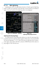
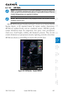
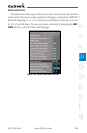
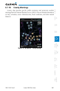
A Stationary Front is a front with very little horizontal movement. The line
alternates with orange and blue sections which point in opposite directions to
symbolize little movement.
Figure 4-43 XM Weather - Stationary Front
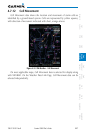
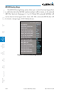
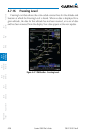
An Occluded Front is where a cold front has overtaken and merged with a
warm front. The line alternates with the blue triangle and orange half moon sym-
bols on the same side of the line pointing in the direction the front is moving.
Figure 4-44 XM Weather - Occluded Front
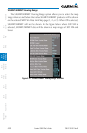
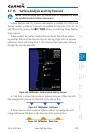
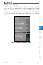
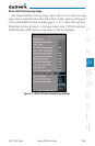
Surface Data Viewing Range
The Surface Data Viewing Range option allows you to select the map range
where at and below that value Surface Data weather products will be shown on
the selected MFD Wx Data Link Map page (1, 2, or 3). When Off is selected,
Surface Data will not be shown. In the figure below where 150 NM is selected,
Surface data will be shown at map ranges of 150 NM and lower.
Figure 4-45 Surface data Viewing Range Selection